Today, we planned on doing a loop to the Monarch Ramparts. By my planning, it was a 21 km circuit with a 700 m height gain. But I blew it; it was actually a 25.6 km circuit with a 1,130 m gain (I misread Patton & Robinson's book, and lost a 4 km section from Simpson Pass to Healy Pass). We caught the 9 AM bus, and started hiking at 9:30, and just barely made the 5:30 PM bus down.
We ran into a very nice lady on the bus who was solo hiking our route but doing the loop part backwards, and not coming back to Sunshine but hiking down Healy Creek to the Sunshine parking lot. More on this later.
The hike starts with a climb out of the ski area up and over Wawa Ridge, offering views on the way up of Mt. Assiniboine over the ski runs...
 |
| Part the way up Meadowlark run |
 |
| The ridge on the left with the slight snow band is the goal |
The trail trucks on through the valley finally intercepting the Continental Divide boundary marker at Simpson Pass.
 |
| BC on the left, Alberta on the right |
 |
| Lakes in the high country |
 |
| The Monarch on the left, the Ramparts in the middle |
 |
| Flowers everywhere you look |
 |
| Flowers, plus The Ramparts on the right, the Monarch centre |
The trail climbs up to Healy Pass (nice, but a little bit uninspired and not a "destination" for a day)...
 |
| Healy Pass |
...and then we started heading down the Ramparts themselves.
 |
| Lakes in the valley and easy walking on the Ramparts |
This was an amazing place, with awesome views in all directions (including back the way we came, where the route follows under the scree field in the trees in the photo below).
 |
| Goat's Eye on the left, Divide on the right |
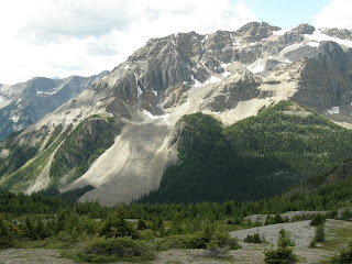
...including an amazing sight: a rock glacier on a mountain that according to my maps has no name in the Ball Range but is the home of Talc (Natalko) Lake.
 |
| The rock glacier on the mountain |
 |
| A close up |
The Ramparts have a trail along them that starts at Healy Pass and goes about 1.5 km down the ridge along the Continental Divide. Then the trail kinda dies on the high flats of the Ramparts where a trail isn't needed, and "restarts" to a crappy trail, that is in places a braided and uncertain path on the descent to Eohippus Lake. You pass a bunch of rocks on the descent where I suspect there's a bunch of pikas, but we had no time to look (see below). Pretty soon you're in the basin below the Monarch, one VERY imposing piece of rock.
 |
| On the descent. The Monarch, up close and personal |
The "trail"/path/flattened grass route leads down to Eohippus Lake (according to my web research, Eohippus was the prehistoric ancestor of the horse who was around 55-45 MM years ago, better known as Hyracotherium). Or it "sort of" leads down to the lake, for the trail kinda just peters out by the lake, and we kinda made our own way for over half a kilometer. The lake itself is nice.
 |
| Eohippus Lake under the Monarch |
According to official guidebooks and maps, a trail runs from here back to the Simpson Pass trail, and it's an official trail (though at this point, we had walked out of Banff National Park, through Kootenay National Park, and were now in Mt Assiniboine Provincial Park, so what constituted an "official" trail was uncertain). We spent 15 minutes looking for this trail, being attacked by horseflies and deer flies, and found something that was similar to a game trail if you closed your eyes and hoped it to be so. We followed it, and in about 1.5 km of wading in knee deep bug infested grass, suddenly a path appeared.
Now, at this point, we noted that we had but 2 scant hours to make it back to Sunshine to catch the last bus down. All my calculations and my GPS tools both on my iPhone (Ski Tracks and Bike Tracks, both of which I highly recommend) and my crappy Garmin said we had 1:45 of walking to get back. So we put our heads down and hustled.
Hustling in the back country is no fun. All you see is your feet. Views disappear. Animals "get in the way". You don't get a break for water or even to catch your breath. And we had a 200 m to climb back up over Wawa Ridge to get back.
We made it back to the village with 20 minutes to spare. Thank goodness (and this is the best part), Sunshine sells beer in the village, so while waiting for the bus, we had a well-earned cold one, nursing all our sore muscles, which were pretty much every muscle in our bodies.
It was a slow wildlife day. We saw about a million Columbian Ground Squirrels...
 |
| This dude let me come within 3' |
...a single marmot...
 |
| Normally they sit still. He didn't. |
...and while we saw no wolves (folks on our bus up reported that there was a family of 5 on the road), we saw their poo.
 |
| The card on the top is 9" long |
We were yelled at by pikas but none would come out to play. We were told of a grizzly sow and three cubs down at Egypt Lake, but didn't go that far, and also heard of bear at Laryx Lake, but never got there. We heard of big mule deer near the top of Standish Chair, but weren't there either.
If I were to do this hike again:
- I would NOT "reverse" the direction. I would stick with Mike Potter's route, going Sunshine to Simpson Pass to Healy Pass to the Ramparts. Do NOT go Sunshine to Simpson Pass to Eohippits to the Ramparts to Healy Pass.
- I would NOT go down the Ramparts all the way to Eohippus Lake. I WOULD wander the Ramparts down the ridge towards the Monarch, but I would turn before as the trail descended into the trees (and the views went to crap). That's the best part of the trail, and the descent to Eohippus adds nothing but time, distance and problematic trail finding;
- I would debate the choice between descending at the end of the day to the parking lot via Healy Creek, versus climbing back up and over Wawa ridge to get back to Sunshine. That last 200 m grunt up was painful at the end of a 26 km day. The downside to heading back to the parking lot is that it's an additional 2.5 km of hiking. But it's all downhill. You gotta make the call based on how you're feeling, and where the cold beer is.
This was a great day, but we were wiped out by the distance and height gain.


No comments:
Post a Comment